
AO-007
 |
Deception Island Call PAZ Mission Opening date: November 1st, 2026 Deadline: Open call - Continuous submission of proposals |
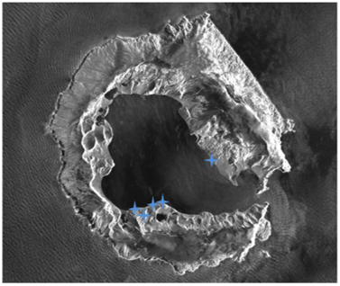
This Call is intended to promote the scientific exploitation of PAZ SAR time series acquired over Deception Island exploitation of PAZ SAR time series acquired over Deception Island, taking advantage of the consistent acquisition geometry and the availability of ground-based corner reflectors deployed across the island.
This unique dataset provides an excellent opportunity to explore the capabilities of SAR techniques, including interferometric analysis (InSAR), ground deformation monitoring, change detection and multi-temporal analysis of surface processes. The combination of high-resolution SAR observations, long-term temporal coverage and accurately georeferenced corner reflectors offers a valuable test site for developing, validating and demonstrating advanced SAR processing techniques and scientific applications in a challenging Antarctic environment.
Within the framework of PAZ_Ciencia scientific exploitation activities, the Spanish National Institute of Aerospace Technology (INTA) announces a new opportunity for the scientific community to access PAZ Synthetic Aperture Radar (SAR) time series acquired over Deception Island, Antarctica.
Deception Island is an exceptional natural laboratory due to its active volcanic nature and unique geological and environmental characteristics. The island offers significant opportunities for research in geodynamics, volcanic activity, ground deformation, seismicity, permafrost and other Antarctic environmental processes.
SAR observations are particularly valuable in this challenging environment, providing all-weather imaging capabilities and enabling the application of advanced techniques, such as SAR interferometry (InSAR), for monitoring surface deformation and investigating geodynamic processes.
Since the 2022/2023 austral summer campaign, INTA has conducted systematic PAZ SAR acquisitions over Deception Island, supported by the deployment and maintenance of radar corner reflectors in collaboration with the Spanish Polar Committee (CPE) and the National Geographic Institute (IGN).
The objective of AO-007 is to promote the scientific exploitation of these SAR time series, making them available to the research community and encouraging new studies and applications focused on Deception Island.
AVAILABLE PAZ SAR DATA
This Announcement of Opportunity provides access to four archived PAZ SAR time series acquired over Deception Island:
| Acquisition Mode | Series | Available from |
| Staring Spotlight | 3351 - ST/ HH / Descending | 2023 |
| Staring Spotlight | 3352 - ST/ VV / Ascending | 2023 |
| Stripmap | 3516 - SM/ VV / Descending | 2025 |
| Stripmap | 2994 - SM/ VV / Ascending | 2025 |
In addition to SAR imagery, the available dataset includes information on the radar corner reflectors deployed on the island, including their reference coordinates in ITRF2020 and identification in the corresponding acquisitions.
The available time series will be progressively extended as new PAZ acquisitions are performed and archived during subsequent Antarctic campaigns.
PROPOSAL SUBMISSION
Researchers interested in accessing the PAZ Deception Island dataset are invited to submit scientific proposals describing their research objectives, methodology, expected results and requested SAR time series.
Proposals must be prepared in English, in Word or PDF format, following the requirements specified in the AO-007 Call Document.
To submit a proposal, applicants must complete the AO-007 Proposal Submission Form.
AO-007 will open on November 1st, 2026, and will remain open indefinitely, allowing proposals to be submitted on a continuous basis.
IMPORTANT DATES
Starting on November the 1st, 2026
 Deception Island Call Document
 Proposal Submission (open on Novemeber the 1st, 2026)
 Contact us for more details paz_ciencia@inta.es glezbmj@inta.es