


ALO
ALO is a mid-range unmanned aerial platform capable of taking off and landing in unprepared runways autonomously. It can be used in multitude of applications.
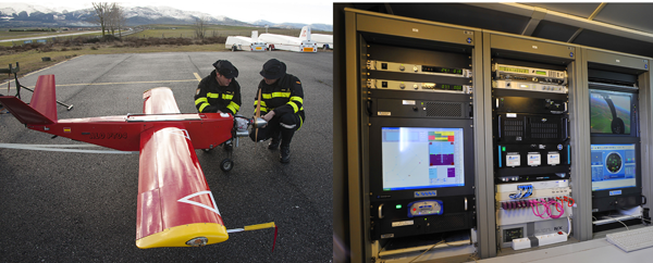
It can provide real time reconnaissance and surveillance images in the visible and infrarred spectrum for mid-range missions equipped with a girostabilized gymbal. The images are transmitted to a Ground Control Station (GCS) to be processed. The GCS includes map and cartography systems for mission planning and monitoring, displaying also relevant flight parameters for UAV control.
Pilot Station includes all the necessary information to monitor the status, attitude and position of the air vehicle. From this application, commands can be sent to both the aircraft and its payload. The system operation is performed complete autonomously including take-off and landing stages (ATOL, Automatic Take-Off and Landing).
Different type of instrumentation can be mounted in the aircraft. The standard payload is a VNIR imager, but it has also been used extensively to collect atmospheric measurements and, in particular, as a platform to take aerosol samples, to assess their content in DNA chains, in the framework of studies to assess the microbial ecology in the atmosphere.
TECHNICAL SPECIFICATIONS
- Dimensions:
- Total length: 2.33 m
- Total height: 0.99 m
- Span: 3.48 m
- MTOW (Maximum Take Off Weight): 60 kg
- Maximum payload: 4 kg
- Maximum operating speed: 180 km/h (97 kts)
- Cruise speed: 115 km/h (62 kts)
- Service ceiling: 4270 m (14000 ft)
- Range: 50 km (27 NM)
- Endurance: 8 h